Cape Caution to Port Hardy
June-July 1996
This is an article from WaveLength Magazine, available in print in North America and globally on the web.
Fog and swell and incredible scenery
by Markus Kellerhal

|
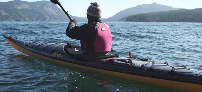
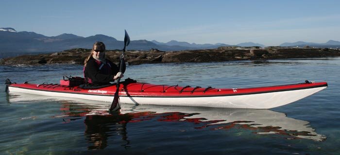
Jill and Chris coming ashore |
A forty mile stretch of mainland coast around Cape Caution is the only part of the Inside Passage not sheltered by offshore islands. This granite-bound coast is not friendly to large ships, but the numerous islands, headlands, and beaches make it a perfect kayak destination. Two friends and I paddled this coast for eight days.
Our trip started at a floatplane dock near Port Hardy where we strapped our three kayaks to the floats of an ancient- looking Beaver. The pilot assured us the plane would still take off, even after we piled our ridiculous amount of gear onto the plane. After endlessly buzzing across the inlet we did indeed lurch into the air.
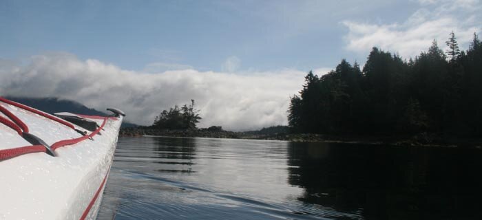
Our flight north took us directly over the coastline that we would be paddling, giving us a spectacular preview of the trip. Granite headlands alternated with golden sand beaches along the coast. Inland the windswept forests were largely untouched by logging -- pleasant change from much of the BC coast.
We landed at Goose Bay, near the mouth of Rivers Inlet. Paddling west out of Rivers Inlet we encountered many sport fishing boats from local lodges. However, once we rounded the first point and were heading south along the open coast we left them behind. We paddled to a sheltered cove at the west end of Open Bight for our first camp site.
The next morning a thick fog moved in. This was to prove a daily occurrence on this trip. Usually the fog burned off later in the day, although occasionally it blanketed us all day. We didn't find the fog to be a big handicap. Indeed it seemed to add to the 'west coast' ambiance. We navigated by compass and by the sound of surf on surrounding reefs. Often the highlight of the day was the magical time when the fog gradually cleared, shapes began to loom out of the grey, and scenic tatters of mist draped the landscape.

We set off through the fog towards our next destination which was Table Island, just off the mouth of Smith Sound. Table Island was labelled "flat and featureless" on our chart -- hardly words to inspire the imagination. In fact it proved to be a very scenic area with an abundance of wildlife and interesting rock formations along the shore.
Our camp was on a minute strip of pebble beach tucked between the main island and a small islet. After setting up camp, Chris and I set off to paddle around the island, while Jill, the keenest hunter-gatherer among us, went fishing. On the west side of Table Island we found exciting paddling threading through boomers and offshore reefs. At the south end of the island we paddled below the lighthouse on tiny Egg Island. Two families of lightkeepers live on this isolated hump of rock.
That night was Jill's birthday. We celebrated with a bottle of wine and a feast of falafel burgers. We watched the sun go down over the ocean and paint the western sky an unearthly purple.
The next day we crossed, again in the fog, back to the mainland coast. The coast south of Smith Sound has an abundance of lovely beaches. We landed through small surf at Blunden Bay and made our next camp there. Not far from the camp were the rusted remains of a shipwrecked barge. Winter storms had pushed the bow section of the barge almost into the forest.
The following day we rounded Cape Caution. The Cape was so named by Captain Vancouver after he ran into rough weather off the coast here. Since that time it has generally been given a wide berth by mariners. Paddling close underneath the granite cliff of the Cape we were tossed around by reflected swell. After the Cape we paddled further offshore to avoid an area of reefs. Fog insulated our senses from everything but the distant sound of surf.
By the time we reached the long sandy sweep of Burnett Bay a strong northwest wind had dispersed the fog. Most of the beach was being swept by large breakers. Only at the very south end was there a landing through smaller waves, perhaps three or four feet high. I landed first and Jill followed. This being Jill's first landing through sizable surf, the subsequent turn of events was fairly predictable. The largest wave of a set picked her up and flipped her despite her valiant efforts at high-bracing.
I dashed into the waves like a hyperactive Saint Bernard to the rescue. Unfortunately I tripped over a loose sandal and stumbled face first into the surf. By the time I had finished coughing up sand and saltwater, both Jill and Chris were safely ashore.
We spent the next two nights camped in Burnett Bay. This is one of the nicest beaches I have seen anywhere in BC. It is a 2.5 mile stretch of smooth golden sand anchored by polished granite headlands at either end. At the south end a sizeable creek cuts through the sand. We were able to follow the creek into an extensive lagoon lying behind the beach.
South of Burnett Bay the character of the coastline changes. There are far fewer beaches along this stretch, and landing spots become more difficult to find. There is also less swell as the coast is partially protected by Vancouver Island. The paddling is less challenging but equally magical as numerous island groups offer a multitude of enticing detours.
Leaving Burnett Bay we paddled past Slingsby Channel to a grassy campspot in a bay with the appealing name of Skull Cove. From camp we rode the tidal current up Schooner Channel to the legendary Nakwakto Rapids. The rapids were a beautiful spot but somewhat anticlimactic. We had heard tales of raging whitewater, but found only fast moving water and a few gentle boils since we were near to slack. We landed on Turret Island in the middle of the rapids and watched the current change direction. By the time we left to ride the ebb current back to camp things had picked up quite a bit -- Turret Island was shedding fair-sized bow waves. I'm sure it must be an impressive place when the current is really moving.
The following day we had hardly left camp when a pod of dolphins shot across our bows at top speed. Minutes later a grey whale sped by, heading in the same direction. We wondered if the whale and dolphins might have been getting out of the way of an orca.
Later that day we paddled by a nice sandy delta in Shelter Bay, which proved to be the last decent campsite along the many miles of coast. We ended up camping in a small cover chock full of floating logs, seaweed and other debris, with about 2 metres square of actual beach. Jill nicknamed the spot "Trash Compactor Cove" because getting from the boats to shore reminded her of the scene in Star Wars where the heroes are trapped in a garbage compactor.
We were quite happy to get back into our boats the next day. Fog periodically surrounded us on the 12-mile crossing of Queen Charlotte Strait. The area where we crossed has a number of island groups that break up the crossing. Many large ships sail through the Strait here, which made crossing in the fog a little unnerving.
Our last night was spent on Balaklava Island. We undertook the final crossing to Port Hardy in dense fog early the next morning. Ferrying across the current in Goletas Channel, we were gratified to hit exactly the point we were aiming for. The dense fog continued right into the harbour at Port Hardy. Everything was quite quiet since it was still early on Sunday morning. We finally realized our trip was over when we saw a supermarket on shore looming out of the mist.
Incredibly, none of this area has park protection of any sort despite the incredible scenery. Judging from what has happened on Vancouver Island, this means that the entire area will be logged right to the waterline or close enough that it makes no difference. At the very least the area around the mouth of Seymour Inlet and the nearby island groups should be made into a marine park. Surely the passage with one of the world's fastest tidal currents is unique enough to deserve this status. A significant chunk of land behind the coast around Cape Caution and Burnett Bay should also be set aside as a protected area.
Markus Kellerhals has been paddling the BC coast for eleven years. Currently he is completing a Master's Degree in Meteorology at the University of British Columbia.


 This site uses valid HTML, CSS and Flash. All content Copyright © 2010 Wild Coast Publishing.